Wednesday, 7 October 2015

Glasgow trip part 2: the isle of Arran!

As I mentioned in my last post, the weather on my recent trip to Scotland was fantastic. My hosts, well versed in the art of caring and feeding for a geologist (and themselves not averse to a bit of fresh air of course!) kindly organised a trip to the island of Arran for me. I was very excited at the prospect for many reasons. Firstly, islands just have an intrinsic coolness factor because they are islands. Secondly, I honestly am not sure when the last time was before this recent trip that I actually saw the sea from ground level. Thirdly, Arran is famous as somewhat of a mecca for British geology students and I had always considered it a mark of slight shame that I had never even touched its shores.

Part of the coolness of islands is that you can use boats to get to them! I have always lived far enough from the sea or other big stretches of water that ferries hold a definite excitement. They combine being big cool machines with the prospect of a journey across the waves AND there's usually a cool view to boot! True to form I thoroughly enjoyed the ferry trip over to Arran, staying out for the whole trip despite the rather strong winds and gazing at the approaching island. You can get a pretty good idea of the geology of the whole place from that distance too, would be a good point to have the first stop of a field trip.

Arran is so famous because it contains in its 30km length a swathe of geology reaching from 500 million years ago to the recent past, encompassing sedimentary, igneous and metamorphic geology of great variety in one easily accessible area. Of course, we only had time to wander over a tiny bit of it, and in any case some of the other people didn't seem to think that we were ONLY there to look at the rocks. Weirdos. In any case, we settled on walking round the shore from our landing point of Brodick, making our goal a prominent castle (of the more stately-home kind) around the bay.

It was absolutely gorgeous sunny weather, and my main impression was of all the different colours on display. The rocks (Permian New Red sandstones) were wonderfully varying hues of red, weathering to a red-tinged sandy beach next to Brodick itself. Seen across the deep blue-green of the sea in sunlight were the much whiter sands more typical of the west coast of Scotland, studded with bright greens from the seaweed and grasses in the sand dunes, and loomed over by the dark greens, purples, browns and greys of the mountains (well in the UK we would say mountains) above.

We walked all the way round the bay, reached the castle and then headed back, stopping to a local bakery to eat a delicious macaroni and cheese pie(!!!). This tasty tasty food nearly scuppered my plan to be awake for the trip home, but I overcame the sleepiness and was able to once again admire the incredible panorama on our trip back to the mainland. Enjoy the bumper pack of photos available at this magic link!

Bis bald,

der Tom.

Saturday, 26 September 2015

Glasgow trip part 1: city

Some of my best friends live in Glasgow, and because they wanted to make my life as easy as possible (I'm sure), decided to share a flat which includes cool pet rats and enough room for tonnes of guests. Glasgow is pretty much always on my list of stops whenever I vist the UK and as such I've been there quite a lot now. This trip was particularly exciting as it was my first visit to the flat when I hadn't either been stressing out about my doctoral thesis or in one case actually writing bits of it while I was there.

Nowadays (there were times when this was different!) my friends are very good at showing me new bits of Glasgow I haven't been to before, and I really think it is a pretty fantastic place. Lots of green, lots of restaurants, plenty of space, impressive architecture and you can get around it quite easily by subway, train, and walking. Not to mention its proximity to the great scenery of the Scottish countryside. Of course, there is one thing that famously isn't always fantastic about Glasgow, and that's the weather. But you won't hear anything about that in this blogpost, because Glasgow at the beginning of September was gloriously sunny for much of the time I was there!

Most of the photos in my gallery of sunny Glasgow pictures were taken in Kelvingrove park, a beautiful park comprising a green and leafy small valley either side of the river Kelvin, towered over by the frankly Harry-potteresque tall tower of Glasgow university and the equally imposing red sandstone bulk and towers of the Kelvingrove Gallery and Museum (also worth a visit!). The hilly nature of the park allows great views over towards the hills surrounding Glasgow, contrasting the cranes and tower blocks with the countryside beyond.

Check out the full gallery of pictures at this here linky thing, and maybe consider a trip to Glasgow if you're ever in the area! I cannot promise it will be sunny though.

Next time, photos from a trip I was taken on while in Glasgow, to the shores of the island of Arran!

Bis bald,

Der Tom

Wednesday, 16 September 2015

Hackney Marshes

I lived a few kilometres away from Hackney Marshes for two years during my stay in London, so of course I never went. The marshes remained an evocatively named and distant patch of green on the google maps representation of the area around my house... until now! On my recent post doctoral-defence trip to Britain I met up with my good friend and former housemate Ed, now a committed Hackney resident and co-owner of two rather active dogs (a whippet and a not-quite-a-whippet), which need their batteries running down if they aren't going to bark at everyone.

Ed suggested we take the dogs (and me) out for a walk in Hackney Marshes, a plan I was very much in favour of! I was slightly sad to discover that the marshes are not some kind of mist and will-o'-the-wisp haunted mystical swampland, but they do preserve some of their more marshy heritage and most importantly represent a massive expanse of green land. We started out in the huge playing field area, the towers of new developments and that weird rollercoaster in the olympic park (people may claim it isn't but I know better) forming the backdrop to people playing cricket. It was a lovely british day, bright sun combining with layers of wind-blown clouds to create a real show in the sky.

We walked on over a bridge, spotting a kingfisher flashing along the fast flowing river below. Moving between hedges of thick brambles we came out into the wilder, grassier area of the marshes. Ripe blackberries were everywhere, though the best efforts of earlier passers by meant that often all the really juicy ones were juuust out of reach! The view that opened up from the path was one that I would not have associated with London at all. In the distance, below the dramatic clouds, trains ran back and forth in front of the spire of a church. In the fields to one side were cows and to the other horses, looking small under the towering power lines.

Hackney marshes are an interesting mixed landscape of playing field, park, river, farmland, and good old London scruffiness. I echo Ed's sentiments that I wish I had discovered them sooner! My favourite photos from the walk are over here at this link, take a look!

As always, bis bald.

Der Tom

Tuesday, 8 September 2015

Winzendorf - Bad Fischau

This hike took place at the end of a several week stretch of hot, hot days in Vienna, with temperatures above 35 degrees in the day and only getting down to 25 degrees even in the middle of the night. The day of the hike was supposed to be the day the heatwave finally broke, indeed in the higher mountains the forecast was for thick cloud and rain. It was decided to do a lower route, with the hope of striking the perfect balance between warm and cold. As it happened all we got was humid, but it was a lovely hike, with great views and some nice surprises.

The route (this time not chosen by me!) started out in the village of Winzendorf on the rail line to Puchberg am Schneeberg, primarily famous for its yearly 'Karl May Festspiele', where the famous (in german-speaking countries anyway) wild west adventure stories of the eponymous author Karl May are acted out. We headed rapidly up onto the low hills, affording us a great view over the Vienna basin and also our future route. In the distance was an exciting-looking castle ruin. After an hour or so's walk we descended into a valley between two hills and climbed steeply up the other side to reach this very ruin, on the Emmerberg.

The vast overgrown complex proved too enticing so we headed in and explored. This castle ruin is at least twice as large as several similar ruins I have encountered hiking elsewhere near Vienna, with substantial walls still standing and fantastic vine-choked masonry. Right at the back of the castle the hill drops away and you get an unobstructed view of the dramatic limestone cliff of the Hohe Wand (literally 'high wall'), which is a sharp fault forming the northern boundary of the Vienna basin. A real shame this magical castle isn't officially open to the public, though with the size of the ruin the costs to make it tourist-friendly would undoubtedly be too large.

After the surprise castle we wandered on over the tops of the hills, accompanied mostly by rank upon rank of the particular species of fir tree that grows everywhere around Vienna in this sort of environment. These firs have beautiful bark on their bare trunks, a silvery sheen and with hints of purple mixed in with the brown. A whole forest of them quickly becomes a strange wall of tree trunks striping away seemingly to infinity. After finding one more viewpoint over the Hohe Wand we turned down towards our destination, Bad Fischau, me half wishing for a cooling thunderstorm that never came. There are a number of caves around the town, although we missed one (hidden somewhere in the undergrowth) and the other is apparently very impressive if you go on a caving tour, but has a tiny unimpressive entrance. No matter, a nice relaxing hike with great views, a perfect choice for repeating in winter too!

As usual, if you click on the link you will get to see the full photo gallery...

And also as usual: bis bald!

Der Tom

Wednesday, 19 August 2015

Crossing the Rax

Today's blog and photos recount a hike across the Rax Plateau that I did a while ago now, near the beginning of July. I was staring at my very mistreated map of the Rax-Schneeberg region wondering what hike I could plan that would be a bit more novel, not just a repeat of the (don't get me wrong, beautiful) hikes I had done before. Summer hikes are great of course, but they can really start to blend together in the head without the aid of new terrain. Summer weather is pleasant but just lacks the changeable nature to really put a unique stamp on each different hike by itself.

I resigned myself to taking the train at the ungodly hour of 7.15 am, as this opens up the whole of the area to access by bus. In the end I decided to start from the tiny hamlet of Hinternasswald right on the southwest side of the Rax, the furthest the bus goes up that particular valley. As I and my intrepid companions who had agreed to come with me despite hearing how many vertical meters were involved (1300) climbed out of the bus around 9.30 am, it was already hot. We were looking forward to avoiding another 38 degree day in Vienna in the cool mountains, but when it's that hot, mountains can only do so much.

The route zigzagged up the back of the Schneealpe before joining the Nasskamm, the fantastic ridge joining Schneealpe to the Rax. I had been thinking of making the climb up to Rax from this ridge ever since we descended from the Schneealpe over it in November last year. The stunning views were tempered a little by the unrelenting sun, and things only got more intense as we set off after lunch up the steepest and rockiest section, a semi-Klettersteig or scramble through some incredible limestone scenery on the steep flank of the Rax plateau. Climbing doggedly in full sun on the south face of the mountain, surrounded by bright reflecting limestone, we sweated and cursed our way up to the top. The rest of the hike was easy and pleasant, the scenery unfolding into wide vistas across the plateau and ending with the pleasantly graded descent to Preiner Gscheid, where we were lucky enough to get a hitch to the station just in time for the (air conditioned!) train. Would have been even more pleasant if we hadn't all been half baked by that point, of course!

All in all a great route, but I wouldn't do 1300m up and 1000m down in the middle of a heatwave again, it was over 25 degrees even up at the highest point, 2007m. I am certainly not ruling out an autumn repeat of this one to get the most out of all the views! Please enjoy the photos from the comfort of your probably much cooler homes!

Bis bald,

der Tom

Wednesday, 22 July 2015

An actual holiday: the Czech Republic

Although I am on permanent holiday in Vienna, it turns out that I am still able to take regular holidays! Actually, I haven't taken a regular holiday where I visit somewhere that isn't the UK for a non-job related purpose in probably over a year, such is the nature of PhD student and ex-pat life. So it was good for me that my good friend Manu was even more in need of a holiday and recommended a trip to the Czech republic. I was very excited, as I have always wanted to see more of the embarrasingly nearby Czech Republic than just Prague.

Manu's tip was that we head to the town of České Budějovice, in the South of the Czech republic and due north of Linz about two hours on a very sleepy slow train, which we later discovered pretty much exactly followed the route of the early 19th century horse drawn railway that connected Linz and
České Budějovice. The town has another name in German, Budweis, and this may give a clue to the major thing that it is famous for outside the Czech Republic, namley its position as the home of (and only production site of) the world renowned Budweiser Budvar beer. It goes without saying that we did the tour, Manu even managing to heroically drag back 40 bottles of the Czech-only budweiser brew in his vast suitcase.

České Budějovice has a beautiful and very peaceful old town absolutely littered with very old and slightly wonky buildings, centred around a vast and very impressive main square, whose highlight is the rather over-the-top town hall with big metal dragon heads protruding from it. Overlooking it all is a large medieval tower providing an excellent view out towards the hills beyond and over the river Vltava (which will later flow through Prague) and the smaller tributary that joins it in Budějovice. My main impression of the place was that it was one of those quiet, beautiful central european towns with abundant parks and enough room for everyone to have a very nice life, though I am sure there are plenty of inhabitants who would still want to swap it for London :-)

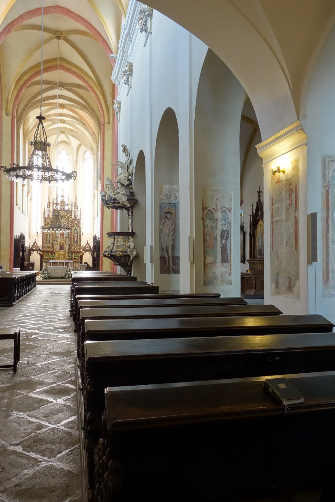
The coolest building in town was in my opinion the Dominican Monastery, a gorgeous gothic church with baroque flourishes, filled to the brim with medieval wall paintings incuding an almost TEN METER HIGH wall painting of St Christopher from around 1450 (apparently he was often depicted as a giant?!). In the nearby village of Hluboká we saw a building that, while not as reserved, was the only thing that topped the monastery, using brute sheer architectural exuberance. The castle, home for many years to the rich and powerful Schwarzenberg family (who had a knack for winning battles of europe wide importance against enemies like the Turks and Napoleon), is currently in its third or fourth incarnation: a mock tudor-style castle modelled after Windsor Castle. The outside is stunning enough, but the insanely complex carved wood panelling and almost casual assortment of vastly expensive objects really blew me away.

Our final day and a night were spent in the nearby (and pretty famous) Český Krumlov, all winding medieval streets, piles of tourists and an impossibly fairytale castle looming high on a cliff over the rest of the small town. We were lucky to have accidentally arrived during a middle ages festival, and proceeded to eat big lumps of grilled pig (I ate so much pig fat on this holiday) and drink rather a lot of Budweiser. Our very successful party evening brought us medieval electric guitar solos, drinking companions from Britain, Canada and the Czech Republic, a firelit procession of medievally clad locals, and a lot of fun! Our journey back to Vienna the next day was subdued but satisfied...


Catch the bumper 16-photo album of what I did on my holidays right at the link!

Bis bald, 

Der Tom

Monday, 13 July 2015

Hohe Veitsch Hike

Among young Vienna based hikers, one object is highly prized: the car. Given the advantages of bikes and public transport for everday transport around the city, most of us city dwellers, especially the non-natives, do not own one. However, it is in the nature of mountainous regions that they are never perfectly accessible by public transport, and the rare offer of someone with a car opens up exciting possibilities beyond the everyday.

This blogpost reports on one such car-assisted trip to a peak I had not climbed until now. There is a whole chain of biggish mountains heading West from the Schneeberg and the Rax, made of the same tough limestone as those two peaks/plateaus. I had visited all of the major limestone mountains in this row between Schneeberg and the Hochschwab but one, the Hohe Veitsch (between the Hochschwab and the Schneealpe, much closer to the latter). We set off on a beautiful sunny summer morning in June.

After a much-more-rapid-than-the-train journey it was time to hike. Starting off in shady forest we crossed occasional hot stretches of felled trees before reaching a gorgeous flowery meadow with isolated trees. The flowers were definitely the theme of this hike, we seemed to have hit exactly the right time and from that point onward the mountain was always colourful. Skirting the edge of a large ridge to avoid going over it, we climbed a steep saddle and easily made it up to the small summit plateau of the Hohe Veitsch. Sweeping grassland with flowers gives way to distant views of the other limeston peaks in the region, and I had great fun at lunch mentally ticking off all the ones I had been on! Especially nice was the view of the whole Hochschwab massif, which I really love to walk in but have never seen a good overview of from a distance before now. The domed head of the Hochschab itself was prominent, as were the snowfields collected in the nooks and crannies of the 2000m high plateau.

We started back down, thinking to get back to Vienna nice and early. A navigating error led us to miss a hairpin bend and continue heading straight, towards the ridge we had skirted earlier. From the back of the group I was pretty sure this wasn't the way we had planned, but quite honestly, I had been eyeing the ridge enviously all day. We reached it, and agreed to take the high road back to the car. This was absolutely the highlight of the walk, scrambling along the very top of the rocky limestone ridge with fantastic views to each side, and the whole place festooned with alpine flowers and almost no other hikers in sight. A brilliant wrong turn! The walk down to the parking place was more direct than the way there and we made it back for a quick icecream in the hut there, later but also happier than planned!

The photos attempting to capture the magical flowers and views can be located by clicking your manual interface device on this text! Hope you enjoy them and maybe it will inspire you to go outside!

Bis Bald,
der Tom

PS the ridge is called der Wildkamm if anyone wants to check it out themselves!