Tuesday, 13 August 2013

Trip to Burgenland

In the second week of July I was privileged enough to be invited along with my housemate to the homeland of my other housemate, who has recently left us to return to that magical land. I have a couple of friends in the area and my housemate had sure spent a lot of time there, so I was curious to check out what made the area so great! The area in question being Burgenland, a reasonably narrow but long strip of a Bundesland which divides the rest of Austria from Hungary and contains Austria's largest lake.

Burgenland is really very close to Vienna, an hour on the train but only maybe 50 km, the train is just quite slow and winds around a lot.We breakfasted at the parents' of another friend, and it was here I was first introduced to one of the coolest things about Burgenland, at least at this time of year: there is food growing EVERYWHERE. I barely had a single fruit or vegetable that had not been grown in the garden or field of the person I was being served it by...

Schloss Esterhazy has some crazy faces on the wall...
Then it was off to examine the main town in the area, Eisenstadt. It is certainly no Vienna in size, but it does have a cool Schloss (Esterhazy) in the middle of it. Having taken the tour and soaked up some grandeur in the Schloss (where Haydn spent a lot of his time as musician in residence), we headed up the hill to one of the oddest churches I have ever visited, a 'Bergkirche'. Basically it contains all the stations of the cross (plus some extra stations they added for extra fun!) inside an artificial, dome shaped rambling building of rough stone. The path winds up, down, in and around and round every corner is another biblical tableaux, until at some point you reach the top and can enjoy the view. Apparently (according to german wikipedia at least) these things weren't so unusual in the 18th century.

The Neusiedlersee and some inhabitants.
Other activities that day included checking out the famous Neusiedlersee, a 36 km long and 6-12 km wide but very shallow (< 2 m) lake surrounded by thick reedbeds and beloved by austrians, holidaymakers and waterbirds alike. In the evening I took my first ever trip to Hungary to eat some Hekk, which appears to be a delicious pike type fish in batter that frankly wasn't too far off a posh british fish and chips! It comes with garlic bread, not chips however.

What Hekk looks like, though mine had no chips!


The following day saw more hanging out by the lake and a trip to the picturesque town of Rust, which is absolutely full of stork nests, perched on little artificial platforms above the chimney. Previous to that occurred the best wildlife sighting of the weekend, when on a visit to a low hill above a large roman quarry (now used for a big opera festival) we were privileged enough to see a Ziesel, or European Ground Squirrel. Not a common thing by any means! The hill by itself was rather cool, it was littered with abstract sculpture left over from a sculptors international conference in the 70s, which gave it a real Salvador Dali air, what with the weird forms intruding on the rolling landscape.

Sculpture park/ Ziesel habitat


We finished off our trip by picking some fresh apricots and courgettes to take back with us. So there you have it, Burgenland, hot, flat, and full of fruit and veg! Oh, and one huge lake and some storks! And lots of people who very much enjoy living there to take advantage of these things...

Have a quick look at the highlights by clicking the green words!

Der Tom

Sunday, 11 August 2013

Schneeberg, 2061 m

It's summer! Things have stopped flooding! It doesn't rain, even when you really, really want it to! When it is summer, you can climb mountains because they are not covered in snow anymore!

Later in the summer I had agreed to go on a 3 day hike in the Alps with some friends. As at least one of these friends runs constantly and has done at least two marathons, I figured it wouldn't hurt to put in a bit of training and get up on some mountains for the month beforehand. Obviously, I also just really, really love mountains.


Today's post and photos concern a hike I did with a couple of Vorarlbergers up the Schneeberg, highest mountain in lower austria and easternmost peak of the alps over 2000 m in elevation. The hike started in drizzle but this quickly evaporated as we walked up the winding track next to the railway which leads up to the plateau near the peak. The railway is pretty cool actually, and it certainly demonstrates how tricky it is for trains to go up steep hills. Once a day on weekends they send the old time steam train up, and it takes 1.5 hours for a climb of 1200 metres! We saw it, and it was a pretty noisy thing. The engine was placed at the back of the train, possibly more to save the passengers from the immense gouts of steam/smoke it was pumping out than anything else... I know there must be a lot of kids that are pretty sure that train is the coolest thing ever though!

 
Once over the lip of the plateau at 1800 m or so it became clear that the sky might have been blue and the sun beaming, but the weather was still not ideal. The wind was about the strongest I have ever experienced on a mountain, and when walking across it you really did have to walk diagonally leaning into it, and it could hold you up! Thankfully, the wind was not evenly distributed over the mountain so we soldiered on to the top, to be greeted with incredible views, reaching even to a faint Vienna in the distance over 60 kilometres away!

Heading down a much steeper and rockier section, we finally reached the bottom of the mountain having done 1500 m up, 1300 m down, and nigh on 20 km horizontal distance! Getting up for work the next day was NOT easy, I can tell you.

Here's some visual highlights!

Der Tom

Thursday, 8 August 2013

Wasserleitungsweg part 2: The Wasserleitungsweg strikes back

As I mentioned in my first post about the amazing series of tubes that bring water to Vienna, the Wasserleitung travels all the way up into the mountains. Along with a large group of mostly russian and bulgarian speaking companions (english very much not the majority language on that hike!) who all wanted a nice Sunday stroll, a month or so ago I set out to walk to the source of one of the big pipes that ensure we have tasty water to drink in the city. It's an easy hike, following the valley cutting through the mountains, rather than going up any off the limestone giants themselves. As most of the hike was along the valley floor, I haven't got too many photos to show you that I think are that impressive. But I did experiment a bit with some long exposures to capture the cool wide mountain stream we encountered further up.


 This stream was obviously textbook habitat for a bird that is rather elusive in Britain, the dipper. I found a whole nest of these interesting streambirds, which like to dive messily in and out of fast flowing streams, and are apparently unimaginatively called 'Wasseramsel' or 'Water-blackbirds' in German. I was very excited to see one, on family holidays in the UK we were always being told that 'there might be dippers about' but I cannot once recall actually seeing one. After getting used to the idea that these birds are mostly invisible, it is a little puzzling to have several of them hopping and flying around with noisy abandon next to one's seat on the pebbles of the riverbed!

A dipper! Top left.
Here's the tiny collection of pictures in full!

Der Tom

Friday, 26 July 2013

Two Towers

... but not *THE* two towers.

I have been trying to get out on a hike at least once a weekend throughout this summer, I really didn't take quite enough advantage of the hiking around here last year and besides, when it is predicted to hit 38 degrees sometime on Sunday, it is clear that leaving the tarmac filled heat sink that is the city centre is just a matter of common sense!

This brief bunch of photos were both taken at the top of lookout towers in the Wienerwald, although the similarities mostly end there. The first group of images were taken atop the 600m Anninger after a pleasant, conifer shaded walk with Ash from the train station at Mödling. I feel sure that I have mentioned the Anninger before, it is one of the higher hills in the immediate vicinity of the city, and seems somewhat higher once you reach the summit as to the East of it lies only the flat Vienna basin. Most of the walk is shrouded in trees, but once you reach the lookout tower you are treated to a magnificent view of the peaks of the Wienerwald, ranging away to the Schneeberg in the distance. I have taken hundreds of photos of this view, but this time some excellent shafts of light breaking through the clouds made it all look just that bit better.


The next small batch of pictures come from a couple of weeks later, on the evening of the summer solstice. I had actually planned to nip up a lookout tower, the Jubiläumswarte that overlooksVienna from its western slopes, in order to catch the sunset. As it turned out, despite a rather brisk walk from the tram stop up into the hills (necessary to avoid the mosquitos, never mind anything else), I managed to miss the actual sun by 10 minutes or so. Shouldn't have spent so long on dinner! Nonetheless I spent a good hour and a half relaxing in the cooler air at the top of the tower, watching it go slowly dark over Vienna. I spent a long time trying to photograph the planes coming in to land at vienna airport, from a good vantage point such as mine one can usually see about three at once strung out in a line getting ready to land...

Enjoy! And I hope it is cooler than 30 degrees in your office right now!

Der Tom

Sunday, 21 July 2013

Wiener Wasserleitungsweg

Apparently in Austria sometimes there are work outings, I suspect possibly just excuses to use spare department money for wine. Anyway, this year for the first time my department had one, where we went for a brief walk in the sun along the path named in the title of this post. After a short time we ended up in the picturesque and wine-filled town of Gumpoldskirchen to enjoy the fruits of its labours and tonnes of very fatty spreads on bread. This is what one does in Gumpoldskirchen.

After the wine drinking was over and everyone was setting out for the somewhat infrequent trains back to Vienna, I decided that I hadn't had enough of the Wasserleitungsweg, and headed off for another hour and a bit, walking through sunset and finally stopping when it was basically too dark to continue. I eventually blundered my way to a train station and went home, much refreshed.

Perhaps I should mention, the Wasserleitungsweg is a path along the slopes at the edge of the Vienna basin which follows the route of one of the large aqueducts that provide Vienna with its famous water. As you were perhaps aware, almost all viennese water is springwater from the alps, piped in two vast aqueducts towards Vienna, the first of which is 140 years old. It is 95km long and the water drops through 270m over its course, meaning that absolutely no pumping is required! The water from a spring in the vicinity of the Schneeberg in the alps delivers around 62 million cubic kilometers of water a year (just over 50% of all the water needed/used) according to the wikipedia article, which is only available in German.

As is traditional, please enjoy the photos I took of the sunset over the vineyards (which I persist in trying to call winegardens even in english nowadays) by clicking on a linky thing.

Der Tom

Todays PS highlights an absolutely incredible installment of NASA's image of the day feature, a photo shot by a crewmember on the international space station showing a view of storm clouds over the atlantic ocean. It is my current desktop, you shall see why!!!


Tuesday, 16 July 2013

Hochwasser

As you may or may not have gathered, the beginning of June saw a rather wet time for central and eastern Europe. Weeks of unseasonal rain swelled rivers to bursting in Germany, the Czech Republic, Austria, Hungary and many other countries. For inhabitants of many towns, cities and villages, this was a stressful, expensive and for a few even deadly time. I say this as I don't want to make light of all the damage done by the floods in the rest of this post, but as many know, the natural world in excess can be beautiful as well as dangerous.

The swirling floodwaters

The reason that allowed me as an inhabitant of Vienna to spend my time gawking and the high waters rather than worrying for my house is Vienna's rather effective flood defence system. In the 70s a whole second channel for the Danube was dug out, the material excavated from this was then used to build an island separating the new and old channels. The new channel, Neue Donau or new Danube, is usually sealed off from the Danube proper by large gates, making it still water and incidentally the only bit of the Danube that is even remotely blue. Together with the 20+ km Danube island, the new Danube spends most of its time being a much loved recreational area of Vienna, affording opportunities to swim, jog, relax, bike, eat pizza or whatever your heart desires, all in easy reach of the main city but somehow a million miles away.

When the floodwaters appear, the gates are opened and the second channel comes into use. With an almost doubled cross section, the Danube can handle much faster and more voluminous flows without breaking its banks. The gates were indeed opened during the most recent flooding, and like a number of Viennese I went out to take a look at our favourite recreational destination being used for its most important purpose! The danube islan and new danube are without a doubt one of the most effective and thoughtful pieces of town planning I know of, and a great example to the world's cities of how to improve and protect yourself at the same time!

The photos I took of this undeniably rather impressive phenomenon can be found as usual by clicking on a link.

Der Tom

BONUS FINNISH FACT: The finnish word for 'world', 'maailma', is an ancient compound of the words for 'earth'/'ground' (maa) and the word for 'air' (ilma)

Sunday, 14 July 2013

Hainburg an der Donau

I am an occasional member of a group of likeminded and extremely international people who like to go for a walk on a Sunday, sometimes this will be an actual 8 hour hike, sometimes a tiny stroll with a bit of culture thrown in. This is the advantage of doing things with non-natives, they are a lot more willing to go see the sights, and/or go see if there are any sights to be seen!

The castle at Hainburg, beneficiary of Richard the Lionheart's misfortune
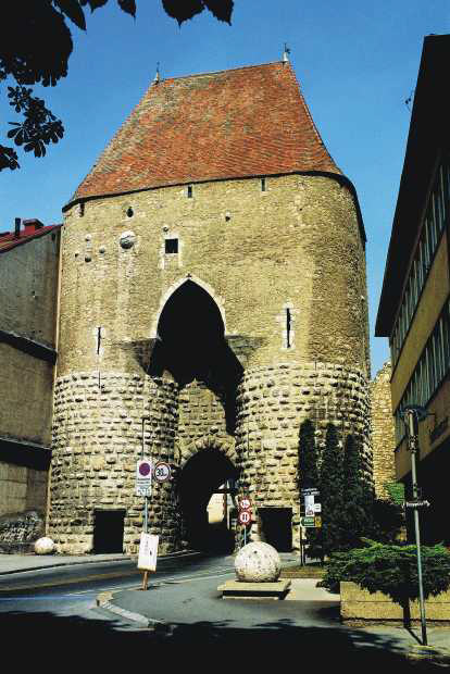
The Sunday we went to Hainburg was one of those Sundays more tourism than hiking tour. Hainburg an der Donau is a town of about 6000 people situated right next to the danube (the clue is in the name!). It has quite a lot to recommend it, touristically speaking. The town centre is still surrounded by high walls built originally in the 13th century, and these are broken only by some rather large medieval gatehouses, one of which houses the comprehensive town museum. Atop the hill above the town is the castle (Burg) alluded to in another part of the name, the destination for our mild stroll. A real proper castle ruin, not a prettified villa or folly, the castle was expanded and improved substantially using the ransom money England paid to get back Richard the Lionheart! Near to the town proper lies the important Roman crossroads settlement of Carnuntum, and the town also includes a museum featuring a number of roman artefacts (and on the day we arrived, some kind of archaeological conference).

Above, one of the medieval town gatehouses!

Hainburg is also almost directly on the border with Slovakia, and is closer to Bratislava than Vienna. From the castle walls Bratislava can be recognised by some of its more famous sights such as the castle. The train line to Bratislava used to run past Hainburg but now the main line runs somewhere else due to a cocktail of historical circumstances, the modern train service runs on only one line and the stations are tiny... The same S-Bahn that terminates after Hainburg goes past the airport, so the train starts out packed and then very quickly empties as you travel across the dead flat of the Vienna basin towards the widely visible hill behind the town. Geologically speaking these hills mark the edge of the Vienna basin, the very end of one little outlier of the alps and, over the river, the start of the slovakian tatras.


Hope you enjoy the small gallery of images, showing a more typical small austrian town instead of the overgrown and beautiful monster metropolis (hah) that is Vienna.

Der Tom

PS stay tuned for a couple more updates soon, I have already sorted and uploaded pictures for them which is always the slowest task, so I should get round to writing about them shortly.